


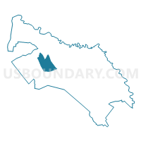
Fall Branch Voting District, Calhoun County, South Carolina
About
Outline

Summary
| Unique Area Identifier | 665214 |
| Name | Fall Branch Voting District |
| County | Calhoun County |
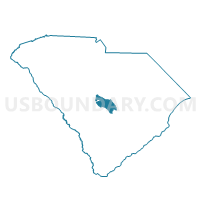
| State | South Carolina |
| Area (square miles) | 11.75 |
| Land Area (square miles) | 11.75 |
| Water Area (square miles) | 0.00 |
| % of Land Area | 100.00 |
| % of Water Area | 0.00 |
| Latitude of the Internal Point | 33.70030630 |
| Longtitude of the Internal Point | -80.88789610 |
Maps

Graphs
Select a template below for downloading or customizing gragh for Fall Branch Voting District, Calhoun County, South Carolina


Neighbors
Neighoring Voting District (by Name) Neighboring Voting District on the Map
- Bethel Voting District, Calhoun County, SC
- Dixie Voting District, Calhoun County, SC
- Murph Hill Voting District, Calhoun County, SC
Top 10 Neighboring County Subdivision (by Population) Neighboring County Subdivision on the Map
- St. Matthews CCD, Calhoun County, SC (6,122)
- Sandy Run-Staley Crossroads CCD, Calhoun County, SC (5,613)